-
What’s Open
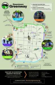
Three of the four mile loop of the Downtown Greenway is now open from Spring Garden Street along Morehead Park to Bragg Street up to Martin Luther King Jr Drive. The newly opened section from Gate City Blvd along Murrow to Greene Street is open and the northern section from Eugene along Fisher to Smith Street is open. Click here for map of open sections.
-
Detour Map
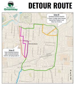
Starting January 29, 2024 there will be two detours in place during construction projects related to the Downtown Greenway. One will be for construction of the final section along the western side, while the other is for bridge repairs in the northeast corner of the Downtown Greenway. You can still enjoy open sections and walk/run/bike the Downtown Greenway today! Click here to view the detour maps — and get moving!
-
Interactive Public Art Map
The Downtown Greenway offers an opportunity to experience beautiful scenery, as well as beautiful art. Venture through the
Downtown Greenway and take in some of the creativity that Greensboro has to offer. -
Connections Map
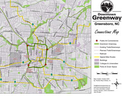
The Downtown Greenway will form a hub that will help connect the 80-plus miles of city greenways and trails that already
exist. It will also connect to a broader network of trails and parks, including statewide efforts, such as the Mountains
to the Sea Trail.
When is the Greenway open?
Morehead Park and Five Points are open from 5:00 am–11:00 pm. The rest of the open sections of the Downtown Greenway are
open 24/7.
What are the rules on the Greenway?
We encourage proper Trail Etiquette
- Yield to pedestrians. Pedestrians always have the right-of-way.
- Keep right and pass on the left. The trail is like a roadway.
- Warn trail users as you approach from behind. Announce yourself; for example, “On your left!”
- If you stop, get off the trail. Always allow other trail users to pass on the left.
- Please be aware of your surroundings. For safety, always carry a cell phone.
- Watch out for maintenance and security needs while on the trail. Report crime and maintenance problems right
away. - Obey all signs and rules. Stop at intersections, travel at safe speeds, and keep to the right.
- Please keep the trail clean. Don’t litter; recycle trash on the trail.
- Please keep animals under control. Keep pets on a short leash, walk pets on the right-hand shoulder, and clean animal
waste from the trail. - Don’t use the trail at night. Morehead Park, Five Points, LoFi Park, Woven Works Park & Meeting Place at Tradition Cornerstone on the Downtown Greenway are open from 5:00 am–11:00 pm. The other open sections of the Downtown Greenway are open 24/7.
Contact Information
Report crime to Greensboro Police Department: 911 Report maintenance problems & all other concerns to: 336-373-3816
Trail Rules & Regulations
- Posted areas of the Downtown Greenway may be closed during specific times (excludes public sidewalk). Morehead Park, Five Points, LoFi Park, Woven Works Park & Meeting Place at Tradition Cornerstone on the Downtown Greenway are closed from 11:00 pm—5:00 am. Do not use the Downtown Greenway during these hours.
- No person shall cause an obstruction of the Greenway that prevents free passage by users.
- Only motor vehicles intended for emergency assistance, safety or maintenance are allowed. Individuals with mobility impairments
may use medical devices. Personal transportation devices used by Law Enforcement are permitted. - Pets and service animals are allowed if under direct control of their keepers, and the control device is not
longer than six feet in length. The owner must remove all waste products left by pets. Horses are not allowed. - No person shall build, light or maintain any fire including grills, portable stoves or heating devices.
- Destructive devices, firearms, edged weapons, and any other types of weapons, including flares or fireworks are
not allowed. - It shall be illegal to remove, deface, alter or destroy any Greenway property, equipment, signs, plants, benches,
art, amenities, fences or any other object associated with the Greenway. - Littering or disposing of any unwanted item(s) of any kind on the Greenway is prohibited.
- Open alcoholic beverages and illegal substances are prohibited. Alcoholic beverages may be allowed only through permitted
special events. - Operating a concession, peddling, soliciting or panhandling is prohibited on the Greenway. Exception: concessions
may be allowed only if necessary permits are obtained and permission granted by the Greensboro Parks and
Recreation Department. - Greenway users shall abide by Greensboro City Code of Ordinances in reference to noise. Loudspeakers and public address
systems are prohibited unless authorized in writing by the appropriate entity. - No loud, abusive, threatening, intrusive or disorderedly conduct is allowed on the Greenway.
- Public users of the Greenway through whatever mechanical means will maintain a speed that does not endanger other trail
users or Greenway property. Bicyclists and skaters should yield to all other trail users. Bicyclists under
the age of 16 are required to wear a safety helmet. Users, including pets and service animals, should stay
on the right side of the Greenway. Greenway users should respect private boundaries of adjacent landowners. - No person or persons should travel on the Greenway in a manner that would endanger other users of the Greenway
or any Greenway property. - The City of Greensboro will not be responsible or liable for items left unattended on the Greenway or any Greenway easement.
Items found unattended will be destroyed.
*These regulations supplement the following: Rules and Regulations Governing the Use of City of Greensboro Parks and Recreation
Areas Within or Without the City Limits. Adopted November 20, 1967 and Amended Through 2007. Reference City Ordinance
19-1 (CO 19-1).